About Us
Bumula Constituency
Was established for the 1997 elections after being hived from Kanduyi constituency in 1996. It covers an area of 347.8km square and has a population of approx. 202,133 persons for 2013 census.
Access NG-CDF Information on your Mobile


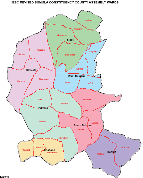
County Assembly Wards in Bumula Constituency :
South Bukusu Ward
- County Assembly Ward No.:
- County Assembly Ward Name: South Bukusu
- County Assembly Ward Population (Approx.):
- County Assembly Ward Area In Sq. Km (Approx.):
- County Assembly Ward Description: comprises part of
Bumula Ward
- County Assembly Ward No.:
- County Assembly Ward Name: Bumula
- County Assembly Ward Population (Approx.):
- County Assembly Ward Area In Sq. Km (Approx.):
- County Assembly Ward Description: comprises part of
Khasoko Ward
- County Assembly Ward No.:
- County Assembly Ward Name: Khasoko
- County Assembly Ward Population (Approx.):
- County Assembly Ward Area In Sq. Km (Approx.):
- County Assembly Ward Description: comprises part of
Kabula Ward
- County Assembly Ward No.:
- County Assembly Ward Name: Kabula
- County Assembly Ward Population (Approx.):
- County Assembly Ward Area In Sq. Km (Approx.):
- County Assembly Ward Description: comprises part of
Kimaeti Ward
- County Assembly Ward No.:
- County Assembly Ward Name: Kimaeti
- County Assembly Ward Population (Approx.):
- County Assembly Ward Area In Sq. Km (Approx.):
- County Assembly Ward Description: comprises part of
West Bukusu Ward
- County Assembly Ward No.:
- County Assembly Ward Name: West Bukusu
- County Assembly Ward Population (Approx.):
- County Assembly Ward Area In Sq. Km (Approx.):
- County Assembly Ward Description: comprises part of
Siboti Ward
- County Assembly Ward No.:
- County Assembly Ward Name: Siboti
- County Assembly Ward Population (Approx.):
- County Assembly Ward Area In Sq. Km (Approx.):
- County Assembly Ward Description: comprises part of